Angle Inlet / Northwest Angle Provincial Forest Border Crossing – Winter Road / Provincial Road 525
This is an unusual border crossing because the entire area is accessible to the rest of Minnesota only by crossing the Lake of the Woods or by coming in from Canada. There is no direct driving route from the US. It is the only part of the United States, outside Alaska, that is north of the 49th parallel. The Angle is accessible by cars, boats or plane during the summer, and also by snowmobile in the winter months.
If you start in the U.S. and travel to Angle Inlet by boat, you’ll never cross a border and will remain in the U.S. the whole time. However, if you drive to Angle Inlet from the U.S., you will need to briefly cross the border and drive through Canada for a bit before crossing back into Angle Inlet.
There is no permanent presence of customs on either side of the Canadian or United States border. HOWEVER, It does not matter how you arrive in Angle Inlet – you risk stiff penalties if you cross the border into Canada, and return to the US, without checking in with the US CBP station. The U.S. Customs and Border Protection has gone so far as to warn Angle Inlet resorts that they could be fined $5,000 if any of their guests returned to the U.S. from Canadian waters without following the correct procedures. Customs officers make patrols in Angle Inlet and have installed cameras providing surveillance over the area.
Procedures for Crossing the Border to Angle Inlet
If you are driving from the U.S., you will most likely enter Manitoba at the nearest Canadian border crossings of Sprague or South Junction, MN. These are north of the U.S. ports of Warroad and Roseau. You will go through Canadian Customs, and then need to re-enter the U.S. To do this, you must report your re-entry into the U.S. to the Warroad US Port by one of three methods:
- Outlying Area Reporting Stations (OARS) located at the Northwest Angle. These are small buildings with video phones that dial directly to the appropriate U.S. or Canadian port of entry.
- Using the ROAM app on CBP Tablets located at resorts and marinas throughout the area. These may include Jim’s Corner, Carlson’s Landing, Young’s Bay, and other participating resorts. It’s a good idea to call ahead to check whether your destination has one of these tablets.
- Use the ROAM app on your cellphone. You will call the Warroad port of entry if you have the Android or iPhone ROAM app installed on your phone.
Using OARS or Roam to Cross the Border
When you reach the Warroad port by any of these methods, tell them you are reporting your arrival in the US or Canada. The officer will ask you a handful of questions, such as: your name; birth date; license plate number; make, year, and model of your vehicle; purpose of travel, if you have alcohol, weapons, etc., and what type of identification you have (passport, passport card, etc.) You must provide the normal documentation you need to cross into both the US and Canada.
When you are ready to leave the Angle Inlet, you must also call in, but this time, push the Canadian flag button in OARS or Roam. This is to let them know you will be driving through Canada to return to the US.
Tips for Crossing the Border at Angle Inlet
- Here is a handy link to hotels in Minnesota, US and here is another link to hotels on the Canadian side of the port in Manitoba, Canada.
- Ice is considered land, so snowmobilers must do the border crossing procedure as well.
- It is about a 60 mile drive from the U.S. / Canadian border on a mix of both asphalt and gravel roads.
- If you are coming from the U.S., make sure you have an international calling plan or you will most likely lose cell service shortly after clearing Canadian customs.
- Residents are given special permits to avoid going into the shack.
- Some travelers recommend that if you are going to be in Canada on a daily, or extended basis, the Remote Area Border Crossing Permit (RABCP) is still the best plan.
- This is one of only four locations in the contiguous United States not directly connected to it – the others are Elm Point, Minnesota; Point Roberts, Washington; and the town of Alburgh, Vermont.
- Commercial carriers are required to stop at the CBSA office in Sprague on the return trip to provide required documentation.
- Longitude and Latitude for Angle Inlet: N 49° (20.750) W 095° (00.350)
What do you do in Angle Inlet?
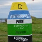
“The Angle,” as the locals call it, is visited by hunters, fishermen, and vacationers looking for water sports and beautiful scenery. In addition, some people come to Angle Inlet to visit the geographic marker which identifies the most northernmost point of the conterminous 48 states.
Manitoba and Minnesota Road Conditions
View our page on current road conditions for the Province of Manitoba which includes information on weather issues, construction and other types of hazards.
ANGLE INLET WEATHERAngle Inlet Port of Entry Location Map
Contact Information for the Angle Inlet Port
You may use the telephone numbers below to contact the customs officials and border patrol officers who staff the ports at this border crossing.
- Warroad U.S. Customs Office Telephone Number: (218) 386-2796.
- Canadian Border Information Service: Call 800 461-9999 from within Canada or 204-983-3500 from outside the country.
